
What the US would look like if each state had an equal population:
An online article by Dylan Stableford redistributing the 50 states by population 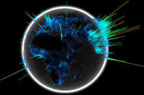
Must See World Maps
40 Maps that will help you make sense of the world. If you’re a visual learner like myself, then you know maps, charts and info graphics can really help bring data and information to life. Maps can make a point resonate with readers and this collection aims to do just that. 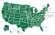
21 Informative Maps That Will Change Your Worldview
We love a good map. Especially one that will make you think twice about the world around you. More than just helping you move from place to place, maps are a great means to easily view information. Wondering what countries are more populous than Bangladesh? Or curious about how many female parliament members there are globally? Luckily, there is something for everyone. Hilarious, Terrible, Yet Mostly Accurate Maps
Maps are freaking cool, and you can get super creative with them. Not only do they provide geographical measurements but also ways to learn about different populations. For instance, did you know that people in Ireland spend the most money on booze? How about the fact that pediatricians have the highest-paying job in Mississippi? Yeah, you can learn a lot from looking at a map. While we love to learn, we also love to laugh. There’s a ton of room for imagination when it comes to creating a map so hilarious it’s terrible. Not sure what we mean? We stumbled upon Terrible Maps on Facebook, which publishes terrible maps that offer a pinch of humor, and then rounded up the best ones for your enjoyment. |

Geography Today
A 'hub' for geography with links to geography and geographers in the media and longer articles that feature the broad range and diversity of geography today. 
Earth from the Hubble
The Hubble Space Telescope is an icon in space. Launched on April 24, 1990, the space telescope has changed how we view the universe around us. See amazing photos of the universe from the Hubble Space Telescope in this Space.com gallery 
Chart Bin
Maps and more maps. If you hare interested in global visualization this site has it all. Food maps, sports maps, religion maps, language maps. If it exists they have it. 
Rare & Antique Maps of the World
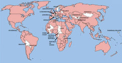
While history books may detail the events of our past that shaped the world, we can see a literal shaping when we take a look at historic maps. Sometimes, we can gain a visual of a long-gone place. Other times, we see the world through the eyes of those who had yet to discover just how far the Earth stretches. Still, others come from those brave enough to explore and charter courses for others. Where in the World is Federalism?
The United States is the world's oldest federal country, and the institutions of federalism established by the Constitution have been durable since 1789. Since then, and especially during the twentieth century, the world experienced what federalism scholar Daniel J. Elazar wrote as an ongoing "federalist revolution" where countries embroiled in internal conflict turn to federalism as a much hoped-for panacea. Why have so many countries turned to federalism? One possible explanation for the widespread adoption of federalism is because it "places a premium on negotiation and bargaining" and is therefore well-suited for a country or group of people which seeks to maximize individual liberty and equality across all parties involved. |

|
|
